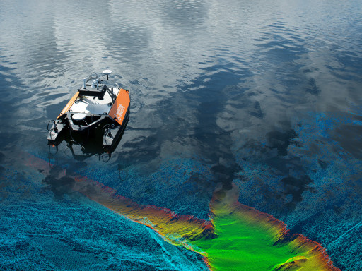
top of page
product_symbols_2.png

Bathymetric Mapping

1809_otter_elv_redigert.jpg
Mapping a Water Reservoir
pasted image 0.jpg
Fosen Road Damage

Mapping a Water Reservoir using the Otter USV with Norbit

Terratec AS, Norway’s largest supplier of geodata, had a problem. They wanted to conduct a multi-beam bathymetry survey on a dam where the access was too limited for their regular survey vessel.


Storfossdammen has an area of 0.17km². The highest regulated water level (hereafter HRV) is 519m and the lowest regulated water level (hereafter LRV) is 503m. The regulation height of 16m gives it a volume of 1.69 million m³.


The Otter USV was controlled remotely via a broadband communications link that has a range of around 2km. For the work up the feeder rivers, the Otter was controlled via Maritime Robotics’ mobile phone application over WiFi.  During the survey the bathymetry data was displayed in real time inMaritime Robotics’ Vehicle Control Station (VCS) software, allowing the operator to fine-tune the acquisition.


The Otter USV is also equipped with a 4G modem that allows an ntrip service to be run on board the vehicle, to get access the national RTK corrections service. This creates significant improvements in localization accuracy, improving data quality.


For final data delivery the software was processed with Qimera from QPS and overlaid with LIDAR data from Kartverket, producing stunning imagery of the dam.  Terratec was then able to deliver improved estimates of dam volume, as they were able to survey more of the extents of the water reservoir with a smaller vehicle.


For sheltered waters with limited access, the Otter USV is a vehicle capable of rapid deployment and easy operation. A cost-effective turn-key solution for bathymetric surveys in sheltered waters.

2018-09-05_12_43_39-2.jpg
Storfossdammen.jpg

Fosen Road Damage

On the main road between Leksvik and Vanvikan in Fosen, north of Trondheim in Norway, a local citizen discovered by chance that the sea had washed away parts of the road foundation.

​

The damaged road was deemed unsafe by authorities and was closed. This created a lot of problems for the local transport of people and goods.


Maritime Robotics decided to perform a detailed mapping of the area around the cave, which had been created by the erosion, as well as a few hundred meters along the coast on both sides. We used our Otter USV and equipped it with the Norbit iWBMSh STX multibeam sonar sensor and the iLIDAR laser scanner.


Maritime Robotics' VCS software was used to set up the area to be mapped.  It was both used to plan and control every aspect of the vessel and its autonomous operations, and to control the Norbit equipment. Very close to shore, as well as inside the cave, the Otter was manually controlled using Maritime Robotics’ mobile phone application.

Water Reservoir
Fosen Road Damage
bottom of page